The Varsity Way: Cambridge to Oxford (Part Two)
18/05/2019 – 22/05/2019
Map (s) used: Sustrans NCN The Varsity Way
Total distance: 205km
This stage: 60km
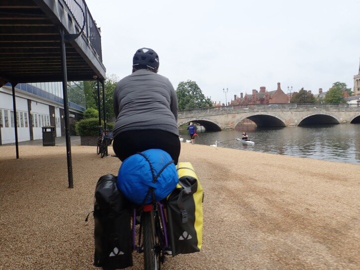
Image description: Abi rides a fully loaded bike through Bedford centre, beside the river. A bridge sits in the distance.
Our first day had brought significant ups and downs but we were keen to leave early the next morning for another long ride. Our destination: Milton Keynes.
DAY TWO: St Neots to Milton Keynes
Abi: We woke up in the morning to light fog and silence which was only broken by the echoes of a loud woodpecker. Lili spotted it as they were cooking porridge, clinging to a tree only a few metres in front of us. We watched it dart about as we ate breakfast, before it disappeared towards the river.
According to the map the majority of the route promised to be off-road, but after the farmer’s tracks of yesterday, neither of us were feeling great about off-road paths. It seemed a quirk of the British cycle network that any path, no matter it’s surface, width or the level at which the surrounding plants had grown over it, was deemed a national cycle route. On top of this, the map (unlike many of it’s European equivalents) does not differentiate between perfectly paved greenway or dodgy gravel tracks, so it was a bit of a lottery about what we might get.
Neither of us were feeling too bad. We’d slept well in the calm of the campsite, and it seemed like our adventures on the southern uplands on the way to Cambridge had laid the foundations for some fitness/stamina. Still, we both winced as we got back on the bikes.
Getting back on the cycle path from the campsite at St Neots was as easy as leaving the main gate: we were immediately there. The path initially led us across fields and over footbridges which spanned marshland, rivers and streams. There was very little traffic and we soon found ourselves on the first stretch of cycle path, a narrow, bumpy footpath which wound around fields and up to the village of Great Barford. From there, another small minor road led to a second cycle path- this one running all the way to Bedford.
Lili had ridden this cycle path before (again, during their mad cycle ride to Milton Keynes one sweltering afternoon) and had good memories of it. The path is part of the National Byway (a sign-posted cycle route which winds from Scotland through Wales and England). It wasn’t perfect, but it was off road and it’s imperfection was mostly due to the split and bumpy tarmac which needed some serious maintenance.
The closer to Bedford we rode, the better the path got and the busier it became with families enjoying the weather. Although this meant more bell-ringing and more swerving to avoid people, it was great to see so many people enjoying a good quality cycle path. If you build it, they will come. The government ploughs money into nonsense healthy eating/getting active campaigns. This would be better spent improving the infrastructure to make the outside more accessible.

Image description: We push our bikes and duck under a low bridge in bedford.
We ate lunch in the centre of Bedford on one of the benches overlooking the river Ouse. Then we continued back on the cycle path, dodging swans and ducking under low bridges. The signing deteriorated a little as we made our way out of Bedford and we were relieved, once again, to have data on our phone to use when we got lost.
Lili: With 10km to go and having enjoyed more low-traffic routes, we were hit with our worst nightmare: a diversion. This one was roadworks on the road we planned to take into Milton Keynes (some bridge that my mum knowingly nodded about the next day when we met her for dinner). We figured there was a possibility they would include space for pedestrians to pass and so we risked it and headed straight down to the blocked road. Unfortunately, there was no way past (not even a track along the side of a field).
There wasn’t even a suggestion of an alternative route for cyclist’s which, considering the road works blocked part of a national cycle route, seemed a bit shitty. We were lucky that we had a map. I was nervous and had a temporary wobble at the roadworks. I didn’t want to ride on the big road and I was sad and stressed and frustrated that I didn’t have another option. THERE SHOULD ALWAYS BE ANOTHER OPTION. It doesn’t matter that I grew up on a bike, or we cycled over 2,000km across Europe, or we cycle nearly every day, we both still sometimes get scared riding on big roads. We joined the busier A-road. Traffic was fast and heavy, but there were markings for cyclists and people passed relatively well. New housing developments and the expansion of Milton Keynes meant we were soon onto cycle path again.

Image description: two route signs attached to a lamppost which point in opposite directions. This was confusing.
In Milton Keynes we immediately noticed how intentional and consistent the cycling infrastructure was. It was completely separate from the busy roads and roundabouts that criss-cross the town. This was ideal in terms of providing a traffic free route, however I’m not sure how safe I’d feel using these routes myself. Riding home from a pub or club, even in Cambridge, I’d stick to the busier roads and I’m not sure how I’d feel about using an off-road cycle route late at night.
We were headed for a campsite beside Gulliver’s themepark, which gave us a reference point to orientate by; although the quality of paths was great, it could have been improved by signage, as, away from traffic and without being able to see roadsigns, it was easy to get lost (which I definitely did on my mad trip to MK before.)
We followed the NCN route around a large pleasure lake, and through a park to the campsite. It was a very simple set up – the majority of space was taken up by wooden cabins, themed to the ‘wild west’ for families at the themepark. We wheeled our bikes past the large sinister vulture brandishing a knife and fork and set up tent. I hadn’t been sure we’d manage two 60km days one after another so early on. I was quietly pleased we had.
We spent a day resting in Milton Keynes. I’ve visited MK many times, as my grandad lived here, but I’d never really appreciated why he waxed lyrical about the town. Riding about, I understood better (I think maybe this is partly because MK is a horrible place to drive about in.) There are parts of MK that are like, super utopian and you really got this sense of this grand idea of how cities should be, and someone attempting to execute this. It was really interesting to see where this succeeded and where it fell down. Making the centre of town two fucking massive shopping malls: dystopian, and killing the opportunities for arts/cultural/community/social stuff there, as well as like smaller, independent businesses. Large areas of parks, lots of off road walking and cycling routes: utopian. Robots which deliver bread and milk: I’m undecided.

Image description: Lili stands in front of a silver pyramid atop a hill in Milton Keynes.
TLDR: This was a v.achievable 60km. The route varied from narrow bumpy footpaths to the beautiful route along the river in Bedford. Signage was at times questionable/incomprehensible and once again, you couldn’t rely just on the sustrans map+signage. Milton Keynes is like a vision of utopia from the 1950s.